
Cape Breton Regional Municipality topographic map
Interactive map
Click on the map to display elevation.
About this map
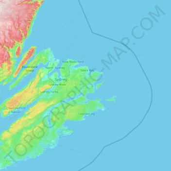
Name: Cape Breton Regional Municipality topographic map, elevation, terrain.
Average elevation: 38 m
Minimum elevation: -2 m
Maximum elevation: 514 m
Other topographic maps
Click on a map to view its topography, its elevation and its terrain.
Milbury Lake
Canada > Nova Scotia > Municipality of the County of Annapolis > Youngs Cove
Average elevation: 163 m