
Thank you for supporting this site ❤️
Make a donation
Make a donation
Periyar River topographic map
Click on the map to display elevation.
Thank you for supporting this site ❤️
Make a donation
Make a donation
About this map
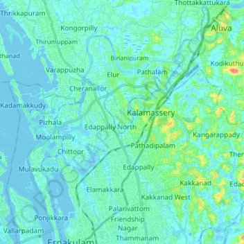
Name: Periyar River topographic map, elevation, terrain.
Location: Periyar River, Kochi, Ernakulam, Kerala, 683108, India (9.98335 76.25781 10.11550 76.35751)
Average elevation: 7 m
Minimum elevation: -5 m
Maximum elevation: 51 m
Thank you for supporting this site ❤️
Make a donation
Make a donation
Other topographic maps
Click on a map to view its topography, its elevation and its terrain.