
Loch Mullardoch topographic map
Interactive map
Click on the map to display elevation.
About this map
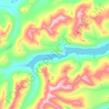
Name: Loch Mullardoch topographic map, elevation, terrain.
Location: Loch Mullardoch, Highland, Schottland, Vereinigtes Königreich (57.30874 -5.17421 57.34104 -4.95385)
Average elevation: 611 m
Minimum elevation: 236 m
Maximum elevation: 1,176 m
Other topographic maps
Click on a map to view its topography, its elevation and its terrain.
Montrose
Vereinigtes Königreich > Schottland > Angus
Montrose, Angus, Schottland, DD10 8QW, Vereinigtes Königreich
Average elevation: 22 m
Glenesk
Vereinigtes Königreich > Schottland > Aberdeenshire > Turriff
Glenesk, Turriff, Aberdeenshire, Schottland, AB53 8BQ, Vereinigtes Königreich
Average elevation: 92 m
Loch Bealach nam Buthan
Vereinigtes Königreich > Schottland > Highland
Loch Bealach nam Buthan, Highland, Schottland, Vereinigtes Königreich
Average elevation: 586 m
Edinburg
Vereinigtes Königreich > Schottland > Edinburg
Edinburg, Schottland, Vereinigtes Königreich
Average elevation: 118 m
Glasgow
Vereinigtes Königreich > Schottland > Glasgow
Glasgow, Glasgow City, Schottland, G2 1DY, Vereinigtes Königreich
Average elevation: 128 m
Millbank
Vereinigtes Königreich > Schottland > Millbank
Millbank, Aberdeenshire, Schottland, AB51 7RX, Vereinigtes Königreich
Average elevation: 181 m
Mull
Vereinigtes Königreich > Schottland
Mull, Argyll and Bute, Schottland, Vereinigtes Königreich
Average elevation: 122 m
North Connel
Vereinigtes Königreich > Schottland > North Connel
North Connel, Argyll and Bute, Schottland, PA37 1PL, Vereinigtes Königreich
Average elevation: 19 m
Kirkwall
Vereinigtes Königreich > Schottland > Kirkwall
Kirkwall, Orkney Islands, Schottland, KW15 1HG, Vereinigtes Königreich
Average elevation: 27 m
Argyll and Bute
Vereinigtes Königreich > Schottland
Argyll and Bute, Schottland, Vereinigtes Königreich
Average elevation: 84 m
Waterton
Vereinigtes Königreich > Schottland > Waterton
Waterton, Aberdeenshire, Schottland, AB41 9QQ, Vereinigtes Königreich
Average elevation: 32 m
Spidean Coire nan Clach (Beinn Eighe)
Vereinigtes Königreich > Schottland
Spidean Coire nan Clach (Beinn Eighe), Highland, Schottland, Vereinigtes Königreich
Average elevation: 608 m
Caldervale
Vereinigtes Königreich > Schottland > Haughhead
Caldervale, Haughhead, South Lanarkshire, Schottland, G71 7RN, Vereinigtes Königreich
Average elevation: 33 m
Skye
Vereinigtes Königreich > Schottland
Skye, Highland, Schottland, Vereinigtes Königreich
Average elevation: 63 m
Ben Nevis
Vereinigtes Königreich > Schottland
Ben Nevis, Highland, Schottland, Vereinigtes Königreich
Average elevation: 912 m
Highland
Vereinigtes Königreich > Schottland
Highland, Schottland, Vereinigtes Königreich
Average elevation: 183 m
Loch Druidibeag
Vereinigtes Königreich > Schottland > Groigearraidh
Loch Druidibeag, B890, Driomor, Groigearraidh, Na h-Eileanan Siar, Schottland, HS8 5RR, Vereinigtes Königreich
Average elevation: 14 m
Orkney
Vereinigtes Königreich > Schottland > Hestwall
Orkney, Brodgar Road, Hestwall, Orkney Islands, Schottland, KW16 3JZ, Vereinigtes Königreich
Average elevation: 9 m
The Table
Vereinigtes Königreich > Schottland
The Table, Highland, Schottland, IV51 9LB, Vereinigtes Königreich
Average elevation: 294 m
Waulkmill Glen Reservoir
Vereinigtes Königreich > Schottland > Parkhouse
Waulkmill Glen Reservoir, Corselet Road, South Nitshill, Parkhouse, Glasgow City, Schottland, G53 7YW, Vereinigtes Königreich
Average elevation: 83 m
Edinburg
Vereinigtes Königreich > Schottland > Edinburg
Edinburg, City of Edinburgh, Schottland, EH1 1BB, Vereinigtes Königreich
Average elevation: 105 m