
Lemhi County topographic map
Interactive map
Click on the map to display elevation.
About this map
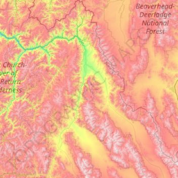
Name: Lemhi County topographic map, elevation, terrain.
Location: Lemhi County, Idaho, United States of America (44.22987 -114.82012 45.70598 -112.81246)
Average elevation: 2,146 m
Minimum elevation: 971 m
Maximum elevation: 3,412 m
Other topographic maps
Click on a map to view its topography, its elevation and its terrain.
Boise
United States of America > Idaho > Boise
Boise, Ada County, Idaho, United States of America
Average elevation: 974 m
Basalt
United States of America > Idaho > Basalt
Basalt, Bingham County, Idaho, 83218, United States of America
Average elevation: 1,398 m
Bear Lake County
United States of America > Idaho
Bear Lake County, Idaho, United States of America
Average elevation: 2,095 m
Corbett Slough Canal
United States of America > Idaho
Corbett Slough Canal, Bingham County, Idaho, 83221-3339, United States of America
Average elevation: 1,377 m