
Bear Lake County topographic map
Interactive map
Click on the map to display elevation.
About this map
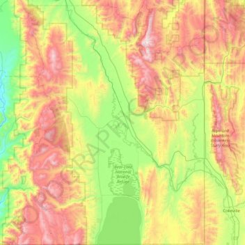
Name: Bear Lake County topographic map, elevation, terrain.
Location: Bear Lake County, Idaho, United States of America (41.99952 -111.63420 42.60329 -111.04668)
Average elevation: 2,095 m
Minimum elevation: 1,488 m
Maximum elevation: 3,014 m
The county is named after Bear Lake, a large alpine lake at an elevation of 5,924 feet (1,806 m) above sea level. The northern half of the 20-mile-long (32 km) lake is in Idaho, the southern half in Utah. The county was established in 1875 in the Idaho Territory, fifteen years before statehood.
Other topographic maps
Click on a map to view its topography, its elevation and its terrain.
Boise
United States of America > Idaho > Boise
Boise, Ada County, Idaho, United States of America
Average elevation: 974 m
Basalt
United States of America > Idaho > Basalt
Basalt, Bingham County, Idaho, 83218, United States of America
Average elevation: 1,398 m
Corbett Slough Canal
United States of America > Idaho
Corbett Slough Canal, Bingham County, Idaho, 83221-3339, United States of America
Average elevation: 1,377 m
Lemhi County
United States of America > Idaho
Lemhi County, Idaho, United States of America
Average elevation: 2,146 m