
Marly topographic map
Interactive map
Click on the map to display elevation.
About this map
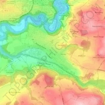
Name: Marly topographic map, elevation, terrain.
Location: Marly, District de la Sarine, Freiburg, 1723, Schweiz (46.76263 7.12130 46.79094 7.18061)
Average elevation: 668 m
Minimum elevation: 549 m
Maximum elevation: 776 m
Marly liegt auf 627 m ü. M., 3,5 km südlich der Kantonshauptstadt Freiburg (Luftlinie). Die Agglomerationsgemeinde erstreckt sich in einer Talweitung der Ärgera (französisch: Gérine), kurz vor ihrer Mündung in die Saane, sowie auf den angrenzenden Molassehöhen des Freiburger Mittellandes.
Other topographic maps
Click on a map to view its topography, its elevation and its terrain.
Granges-Paccot
Schweiz > Freiburg > District de la Sarine > Granges-Paccot > Granges-Paccot
Granges-Paccot, District de la Sarine, Freiburg, 1763, Schweiz
Average elevation: 605 m