
Make a donation
Azhikode topographic map
Click on the map to display elevation.
Make a donation
About this map
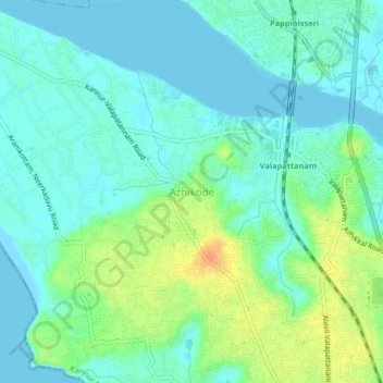
Name: Azhikode topographic map, elevation, terrain.
Location: Azhikode, Kannur, Kannur District, Kerala, 670009, India (11.90356 75.31607 11.94356 75.35607)
Average elevation: 12 m
Minimum elevation: -2 m
Maximum elevation: 40 m
Make a donation
Other topographic maps
Click on a map to view its topography, its elevation and its terrain.
Kannur
Kannur has an elevation of 1.02 metres or 3.3 feet along the coast of the Laccadive Sea, with a sandy coastal area. The city has an 8 kilometres (5.0 mi)-long seashore and a 3 kilometres (1.9 mi)-long beach at Payyambalam. Kannur is located north of Kozhikode, south of Kasargod and Mangalore, west of the…
Average elevation: 14 m
Make a donation
Kannur
Kannur has an elevation of 1.02 metres or 3.3 feet along the coast of the Laccadive Sea, with a sandy coastal area. The city has an 8 kilometres (5.0 mi)-long seashore and a 3 kilometres (1.9 mi)-long beach at Payyambalam. Kannur is located north of Kozhikode, south of Kasargod and Mangalore, west of the…
Average elevation: 14 m