
Halloluwa topographic map
Interactive map
Click on the map to display elevation.
About this map
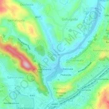
Name: Halloluwa topographic map, elevation, terrain.
Location: Halloluwa, Kandy District, Central Province, 32350, Sri Lanka (7.27073 80.58710 7.31073 80.62710)
Average elevation: 522 m
Minimum elevation: 441 m
Maximum elevation: 748 m
Other topographic maps
Click on a map to view its topography, its elevation and its terrain.
upper division, north meddecombra
Sri Lanka > Central Province > upper division, north meddecombra
Average elevation: 1,268 m