
Lawrenceburg topographic map
Interactive map
Click on the map to display elevation.
About this map
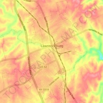
Name: Lawrenceburg topographic map, elevation, terrain.
Location: Lawrenceburg, Anderson County, Kentucky, United States (38.00691 -84.93458 38.06107 -84.87269)
Average elevation: 244 m
Minimum elevation: 179 m
Maximum elevation: 275 m
Other topographic maps
Click on a map to view its topography, its elevation and its terrain.
Sparrow
United States > Kentucky > Anderson County
Sparrow, Anderson County, Kentucky, United States
Average elevation: 230 m
Lawrenceburg
United States > Kentucky > Anderson County > Lawrenceburg > Lawrenceburg
Lawrenceburg, Anderson County, Kentucky, 40342, United States
Average elevation: 242 m