
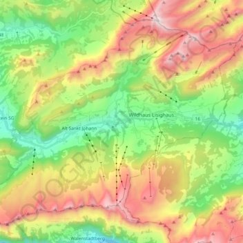
Wildhaus-Alt St. Johann topographic map
Interactive map
Click on the map to display elevation.
About this map
Name: Wildhaus-Alt St. Johann topographic map, elevation, terrain.
Average elevation: 1,453 m
Minimum elevation: 718 m
Maximum elevation: 2,479 m
Other topographic maps
Click on a map to view its topography, its elevation and its terrain.
Unterwasser
Schweiz > St. Gallen > Wahlkreis Toggenburg > Wildhaus-Alt St. Johann
Unterwasser, Wildhaus-Alt St. Johann, Wahlkreis Toggenburg, St. Gallen, 9657, Schweiz
Average elevation: 1,172 m
Älpli
Schweiz > St. Gallen > Wahlkreis Toggenburg > Mosnang
Älpli, Mosnang, Wahlkreis Toggenburg, St. Gallen, 9613, Schweiz
Average elevation: 857 m
Ebnat-Kappel
Schweiz > St. Gallen > Wahlkreis Toggenburg
Ebnat-Kappel, Wahlkreis Toggenburg, St. Gallen, 9642, Schweiz
Average elevation: 1,012 m
Brunnadern
Schweiz > St. Gallen > Wahlkreis Toggenburg > Neckertal
Brunnadern, Neckertal, Wahlkreis Toggenburg, St. Gallen, Schweiz
Average elevation: 853 m