
Thank you for supporting this site ❤️
Make a donation
Make a donation
Lanja topographic map
Click on the map to display elevation.
Thank you for supporting this site ❤️
Make a donation
Make a donation
Lanja
Lanja is a small town located at 16°51′N 73°33′E / 16.85°N 73.55°E / 16.85; 73.55. It has an average elevation of 166 metres (544 feet). It's a Taluka head in Ratnagiri district. National highway popularly known as Mumbai-Goa Highway passes through it. Nearest rail head is Adavali on Konkan railway which is around 15 km away.
Thank you for supporting this site ❤️
Make a donation
Make a donation
About this map
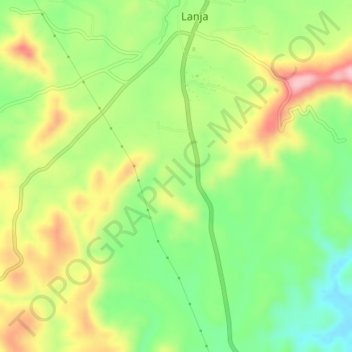
Name: Lanja topographic map, elevation, terrain.
Location: Lanja, Lanja Taluka, Ratnagiri, Maharashtra, 416701, India (16.81896 73.50869 16.89896 73.58869)
Average elevation: 145 m
Minimum elevation: 53 m
Maximum elevation: 249 m
Thank you for supporting this site ❤️
Make a donation
Make a donation