
Thank you for supporting this site ❤️
Make a donation
Make a donation
Antelope Canyon topographic map
Click on the map to display elevation.
Thank you for supporting this site ❤️
Make a donation
Make a donation
About this map
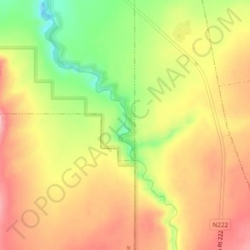
Name: Antelope Canyon topographic map, elevation, terrain.
Location: Antelope Canyon, Coconino County, Arizona, United States (36.92755 -111.42537 36.93524 -111.42103)
Average elevation: 1,202 m
Minimum elevation: 1,121 m
Maximum elevation: 1,260 m
Thank you for supporting this site ❤️
Make a donation
Make a donation
Other topographic maps
Click on a map to view its topography, its elevation and its terrain.
Williams
United States > Arizona > Coconino County
Bill Williams Mountain rises to an elevation of 9,256 feet (2,821 m) just south of Williams. According to the United States Census Bureau, the city has a total area of 43.8 square miles (113 km2), of which 43.5 square miles (113 km2) is land and 0.3 square miles (0.78 km2), or 0.66%, is water.
Average elevation: 2,131 m
Thank you for supporting this site ❤️
Make a donation
Make a donation