
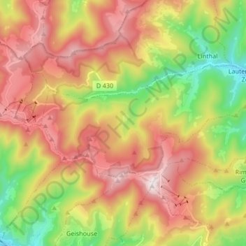
Lautenbachzell topographic map
Interactive map
Click on the map to display elevation.
About this map
Name: Lautenbachzell topographic map, elevation, terrain.
Average elevation: 912 m
Minimum elevation: 414 m
Maximum elevation: 1,419 m
Le village de Lautenbachzell et son important hameau Sengern sont blottis dans la belle vallée du haut Florival avec sur son flanc nord l'imposant massif du Grand Ballon (1 424 m). L'altitude du village varie entre 350 et 420 mètres et le point le plus haut dans la montagne faisant partie du banc de Lautenbachzell se trouve à 1 415 mètres. Le village est situé au cœur du parc naturel régional des Ballons des Vosges et s'étire sur une longueur de 7 kilomètres le long de la rive droite de la Lauch. Lautenbachzell est une commune de montagne qui a une superficie de 232 ha, dont 1 781 ha de forêt. L'accès du village se fait par l'est, en traversant le pont de la Lauch en face du village de Lautenbach, en venant de la route départementale 430 par Guebwiller ou depuis la route nationale 83 par l'ouest, en allant vers la route des Crêtes par Le Markstein. Les deux villages et les différents lieux-dits sont desservis par 22 kilomètres de voies communales.
Other topographic maps
Click on a map to view its topography, its elevation and its terrain.
Westhalten
France > Grand Est > Haut-Rhin
Westhalten, Thann-Guebwiller, Haut-Rhin, Grand Est, France métropolitaine, 68250, France
Average elevation: 336 m
Bantzenheim
France > Grand Est > Haut-Rhin
Bantzenheim, Mulhouse, Haut-Rhin, Grand Est, France métropolitaine, 68490, France
Average elevation: 219 m
Fessenheim
France > Grand Est > Haut-Rhin
Fessenheim, Colmar-Ribeauvillé, Haut-Rhin, Grand Est, France métropolitaine, 68740, France
Average elevation: 208 m
Valdieu-Lutran
France > Grand Est > Haut-Rhin
Valdieu-Lutran, Altkirch, Haut-Rhin, Grand Est, France métropolitaine, 68210, France
Average elevation: 352 m
Zillisheim
France > Grand Est > Haut-Rhin
Zillisheim, Mulhouse, Haut-Rhin, Grand Est, France métropolitaine, 68720, France
Average elevation: 304 m
La Trinque
France > Grand Est > Haut-Rhin > Labaroche
La Trinque, Labaroche, Colmar-Ribeauvillé, Haut-Rhin, Grand Est, France métropolitaine, 68910, France
Average elevation: 732 m
Hagenthal-le-Bas
France > Grand Est > Haut-Rhin
Hagenthal-le-Bas, Mulhouse, Haut-Rhin, Grand Est, France métropolitaine, 68220, France
Average elevation: 395 m
Guebwiller
France > Grand Est > Haut-Rhin
Guebwiller, Thann-Guebwiller, Haut-Rhin, Grand Est, France métropolitaine, 68500, France
Average elevation: 379 m
Masevaux-Niederbruck
France > Grand Est > Haut-Rhin > Masevaux-Niederbruck
Masevaux-Niederbruck, Thann-Guebwiller, Haut-Rhin, Grand Est, France métropolitaine, 68290, France
Average elevation: 577 m
Ottmarsheim
France > Grand Est > Haut-Rhin
Ottmarsheim, Mulhouse, Haut-Rhin, Grand Est, France métropolitaine, 68490, France
Average elevation: 224 m
Wittelsheim
France > Grand Est > Haut-Rhin
Wittelsheim, Mulhouse, Haut-Rhin, Grand Est, France métropolitaine, 68310, France
Average elevation: 262 m
Schlierbach
France > Grand Est > Haut-Rhin
Schlierbach, Mulhouse, Haut-Rhin, Grand Est, France métropolitaine, 68440, France
Average elevation: 276 m