
Veľký Kýr topographic map
Interactive map
Click on the map to display elevation.
About this map
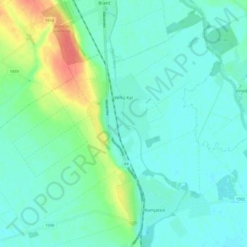
Name: Veľký Kýr topographic map, elevation, terrain.
Average elevation: 135 m
Minimum elevation: 123 m
Maximum elevation: 175 m
The municipality lies at an altitude of 130 metres and covers an area of 23.638 km². It has a population of about 3095 people.
Other topographic maps
Click on a map to view its topography, its elevation and its terrain.
Bíňa
Slovakia > Region of Nitra > District of Nové Zámky
Bíňa, District of Nové Zámky, Region of Nitra, Western Slovakia, 943 56, Slovakia
Average elevation: 137 m
Šarkan
Slovakia > Region of Nitra > District of Nové Zámky
Šarkan, District of Nové Zámky, Region of Nitra, Western Slovakia, Slovakia
Average elevation: 159 m
Kolta
Slovakia > Region of Nitra > District of Nové Zámky
Kolta, District of Nové Zámky, Region of Nitra, Western Slovakia, 941 33, Slovakia
Average elevation: 204 m