
New Town topographic map
Interactive map
Click on the map to display elevation.
About this map
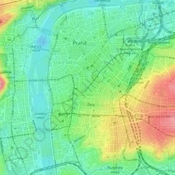
Name: New Town topographic map, elevation, terrain.
Location: New Town, Prague, Czechia (50.06573 14.41089 50.09450 14.44323)
Average elevation: 215 m
Minimum elevation: 177 m
Maximum elevation: 323 m
By contrast, in the largely unsettled area to the east of the road to the Vyšehrad, a planned system of broad parallel roads were built in a grid pattern, which is still clearly visible today. Two of these roads, each nearly 27 meters wide, formed a crossroads at the cattle market and carried the grain trade; they came to be known as Rye Lane (Žitná ulice) and Barley Lane (Ječná ulice). At the end of Barley Lane (also known as Pig Lane (Svinský trh, Svinská ul.), since it likewise served the small animal trade) near the old St John at the Battlefield Church (Kostel sv. Jan Na bojišti) stood the fourth gate, the Pig Gate (Svinská brána) or St. John's Gate. While the other gates consisted of a passage and two flanking towers, St John's Gate was built as a fortress. It consisted of a central courtyard with barrel-curved arched rooms on both sides, over it was an overhanging lintel with eight corner towers and a further higher tower standing over the gate entrance. The gate also protected the entrance of a brook into the New Town, whose water also fed the fish pond of the former settlement, Rybníček. (The gate was torn down between 1891 and 1897 with the adjacent city wall, but during construction work on the Metro station I. P. Pavlova, remainders of the gate were found as well as some tiles with old provincial coats-of arms as well as fragments of a relief with the Bohemian lion which were saved and today stand in the entry of the station.) Apart from the two water gates, the St. John's Gate formed the last access until the east gate of the Vyšehrad, so all the other routes south of Barley Lane also converged on this gate. These were probably roads of older origin and were developed without a strict plan to adapt to the complicated elevations within this area; apart from church plots this area remained to a large extent vacant.