
Ferrere topographic map
Interactive map
Click on the map to display elevation.
About this map
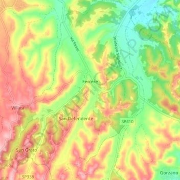
Name: Ferrere topographic map, elevation, terrain.
Location: Ferrere, Asti, Piémont, 14012, Italie (44.84653 7.96468 44.89918 8.01713)
Average elevation: 250 m
Minimum elevation: 166 m
Maximum elevation: 335 m
Other topographic maps
Click on a map to view its topography, its elevation and its terrain.
Briccalone
Italie > Piémont > Asti > Asti > Serravalle
Briccalone, Serravalle, Asti, Piémont, Italie
Average elevation: 199 m