
Thank you for supporting this site ❤️
Make a donation
Make a donation
Novooleksandrivka topographic map
Click on the map to display elevation.
Thank you for supporting this site ❤️
Make a donation
Make a donation
About this map
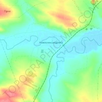
Name: Novooleksandrivka topographic map, elevation, terrain.
Location: Novooleksandrivka, Luhansk Oblast, 94482, Ukraine (48.25425 39.60213 48.27378 39.65585)
Average elevation: 100 m
Minimum elevation: 71 m
Maximum elevation: 153 m
Thank you for supporting this site ❤️
Make a donation
Make a donation
Other topographic maps
Click on a map to view its topography, its elevation and its terrain.