
Thank you for supporting this site ❤️
Make a donation
Make a donation
Sissu topographic map
Click on the map to display elevation.
Thank you for supporting this site ❤️
Make a donation
Make a donation
About this map
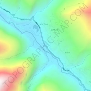
Name: Sissu topographic map, elevation, terrain.
Location: Sissu, Lahul, Lahaul and Spiti, Himachal Pradesh, India (32.44885 77.11233 32.48885 77.15233)
Average elevation: 3,404 m
Minimum elevation: 2,983 m
Maximum elevation: 4,489 m
Thank you for supporting this site ❤️
Make a donation
Make a donation
Other topographic maps
Click on a map to view its topography, its elevation and its terrain.