
Thank you for supporting this site ❤️
Make a donation
Make a donation
Finchingfield topographic map
Click on the map to display elevation.
Thank you for supporting this site ❤️
Make a donation
Make a donation
About this map
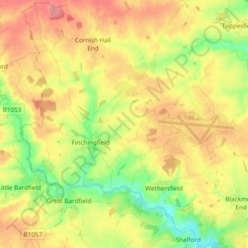
Name: Finchingfield topographic map, elevation, terrain.
Location: Finchingfield, Braintree, Essex, England, United Kingdom (51.93278 0.41383 52.01553 0.51835)
Average elevation: 86 m
Minimum elevation: 46 m
Maximum elevation: 123 m
Thank you for supporting this site ❤️
Make a donation
Make a donation
Other topographic maps
Click on a map to view its topography, its elevation and its terrain.