Ward 167 topographic map
Interactive map
Click on the map to display elevation.
About this map
![Ward 167 topographic map, elevation, terrain](/pub/maps/relation/bz3l/wfb9s8/thumbnail.jpg)
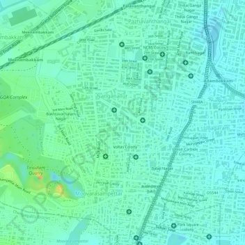
Name: Ward 167 topographic map, elevation, terrain.
Location: Ward 167, Zone 12 Alandur, Alandur, Tamil Nadu, 600 061, India (12.96801 80.17868 12.98636 80.19395)
Average elevation: 16 m
Minimum elevation: 5 m
Maximum elevation: 42 m
Other topographic maps
Click on a map to view its topography, its elevation and its terrain.
![Velachery Lake topographic map, elevation, terrain](/pub/maps/way/dss8/sksvfb3/icon.jpg)
Velachery Lake
India > Tamil Nadu > Alandur > Chennai
Velachery Lake, Ward 177, Zone 13 Adyar, Chennai, Alandur, Chennai District, Tamil Nadu, 600001, India
Average elevation: 10 m
![St.Thomas Mount-Pallavaram Cantonment Board topographic map, elevation, terrain](/pub/maps/relation/7dz4/9sxm14/icon.jpg)
St.Thomas Mount-Pallavaram Cantonment Board
India > Tamil Nadu > Alandur
St.Thomas Mount-Pallavaram Cantonment Board, Alandur, Tamil Nadu, 600016, India
Average elevation: 13 m
![Mugalivakkam topographic map, elevation, terrain](/pub/maps/node/x5t6/trlm2nx/icon.jpg)
Mugalivakkam
India > Tamil Nadu > Alandur
Mugalivakkam, Alandur, Tamil Nadu, 600125, India
Average elevation: 14 m
![Kolapakkam topographic map, elevation, terrain](/pub/maps/node/3d1h/g72qkz4/icon.jpg)
Kolapakkam
India > Tamil Nadu > Alandur
Kolapakkam, Alandur, Tamil Nadu, 600125, India
Average elevation: 14 m
![St. Thomas Mount Cantonment topographic map, elevation, terrain](/pub/maps/relation/3gm2/wdk9s8/icon.jpg)
St. Thomas Mount Cantonment
India > Tamil Nadu > Alandur
St. Thomas Mount Cantonment, Alandur, Chennai, Tamil Nadu, 600016, India
Average elevation: 13 m
![Madanandapuram topographic map, elevation, terrain](/pub/maps/node/p851/9fzbdgt/icon.jpg)
Madanandapuram
India > Tamil Nadu > Alandur > Thelliyaragaram
Madanandapuram, CMWSSB Division 156, Ward 156, Zone 12 Alandur, Thelliyaragaram, Alandur, Tamil Nadu, 600125, India
Average elevation: 16 m