
Thank you for supporting this site ❤️
Make a donation
Make a donation
Santa Maria topographic map
Click on the map to display elevation.
Thank you for supporting this site ❤️
Make a donation
Make a donation
About this map
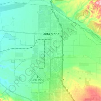
Name: Santa Maria topographic map, elevation, terrain.
Average elevation: 86 m
Minimum elevation: 30 m
Maximum elevation: 271 m
Thank you for supporting this site ❤️
Make a donation
Make a donation
Other topographic maps
Click on a map to view its topography, its elevation and its terrain.
Hope Ranch
United States > California > Santa Barbara County
Hope Ranch occupies a hilly area immediately adjacent to the coast; the highest elevation is 691 feet (211 m). The northern boundary of the hilly area is Cieneguitas Creek, which flows down the topographic expression of the More Ranch Fault; this ravine also helps define the informal northern boundary of the…
Average elevation: 43 m