
Lauberhorn topographic map
Interactive map
Click on the map to display elevation.
About this map
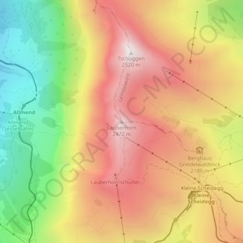
Name: Lauberhorn topographic map, elevation, terrain.
Average elevation: 1,975 m
Minimum elevation: 1,367 m
Maximum elevation: 2,496 m
Other topographic maps
Click on a map to view its topography, its elevation and its terrain.
Männlichen
Switzerland > Bern > Interlaken-Oberhasli administrative district > Grindelwald
Männlichen, Grindelwald, Interlaken-Oberhasli administrative district, Oberland administrative region, Bern, 3818, Switzerland
Average elevation: 1,709 m
Eiger
Switzerland > Bern > Interlaken-Oberhasli administrative district > Grindelwald
Eiger, Grindelwald, Interlaken-Oberhasli administrative district, Oberland administrative region, Bern, 3818, Switzerland
Average elevation: 2,944 m