
Pituffik topographic map
Interactive map
Click on the map to display elevation.
About this map
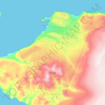
Name: Pituffik topographic map, elevation, terrain.
Location: Pituffik, Greenland (76.31621 -69.21088 76.59271 -67.75681)
Average elevation: 273 m
Minimum elevation: 0 m
Maximum elevation: 828 m
Other topographic maps
Click on a map to view its topography, its elevation and its terrain.
Traill-iup Immikkeertivi
Traill-iup Immikkeertivi, Sermersooq, Greenland
Average elevation: 0 m
Geographical Society Island
Geographical Society Island, Sermersooq, Greenland
Average elevation: 178 m