
Shovi topographic map
Interactive map
Click on the map to display elevation.
About this map
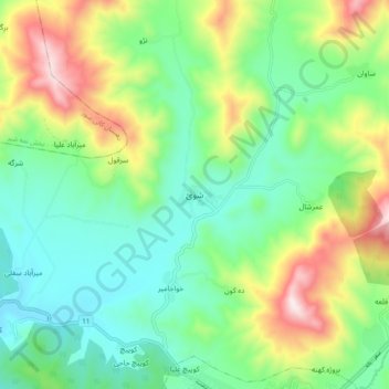
Name: Shovi topographic map, elevation, terrain.
Location: Shovi, بخش مرکزی, Baneh County, Kurdistan Province, Iran (36.00829 45.82219 36.08829 45.90219)
Average elevation: 1,637 m
Minimum elevation: 1,409 m
Maximum elevation: 2,116 m
Other topographic maps
Click on a map to view its topography, its elevation and its terrain.
Bilu
Iran > Kurdistan Province > Baneh County > Kani Sur
Bilu, Kani Sur, بخش نمه شیر, Baneh County, Kurdistan Province, Iran
Average elevation: 1,730 m
Choman
Iran > Kurdistan Province > Baneh County > دهستان بوالحسن
Choman, دهستان بوالحسن, بخش نمه شیر, Baneh County, Kurdistan Province, Iran
Average elevation: 1,099 m
Kandal
Iran > Kurdistan Province > Baneh County > Kani Sur
Kandal, Kani Sur, بخش نمه شیر, Baneh County, Kurdistan Province, Iran
Average elevation: 1,525 m