Geolocate

Ophir topographic map

Interactive map

Click on the map to display elevation.

About this map

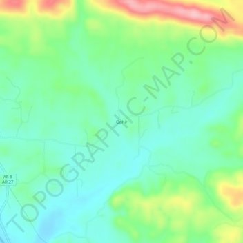
Name: Ophir topographic map, elevation, terrain.

Location: Ophir, Montgomery County, Arkansas, United States (34.42038 -93.63130 34.46038 -93.59130)

Average elevation: 238 m

Minimum elevation: 190 m

Maximum elevation: 349 m

Other topographic maps

Click on a map to view its topography, its elevation and its terrain.

Joplin

United States > Arkansas > Montgomery County

Joplin, Montgomery County, Arkansas, United States

Average elevation: 231 m

Sims

United States > Arkansas > Montgomery County

Sims, Montgomery County, Arkansas, 71969, United States

Average elevation: 227 m

Mount Ida

United States > Arkansas > Montgomery County

Mount Ida, Montgomery County, Arkansas, United States

Average elevation: 215 m

Norman

United States > Arkansas > Montgomery County

Norman, Montgomery County, Arkansas, 71960, United States

Average elevation: 227 m

Mount Ida

United States > Arkansas > Montgomery County > Mount Ida

Mount Ida, Montgomery County, Arkansas, United States

Average elevation: 215 m

Mount Ida

United States > Arkansas > Montgomery County > Mount Ida > Mount Ida

Mount Ida, Montgomery County, Arkansas, United States

Average elevation: 216 m