
Viseu topographic map
Interactive map
Click on the map to display elevation.
About this map
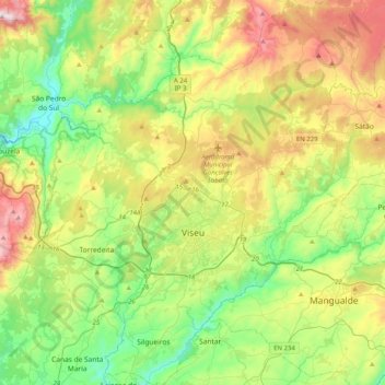
Name: Viseu topographic map, elevation, terrain.
Location: Viseu, Portugal (40.53573 -8.09159 40.84260 -7.75898)
Average elevation: 469 m
Minimum elevation: 146 m
Maximum elevation: 1,067 m
The Municipality is characterized by an irregular surface with altitudes ranging between 400 and 700 metres (1,300 and 2,300 feet). With a rough terrain, it has numerous water courses. These are found in three basins: the Vouga, the Dão and the Paiva.
Other topographic maps
Click on a map to view its topography, its elevation and its terrain.
Adega do Chão
Adega do Chão, Cambres, Lamego, Viseu, 5100-381, Portugal
Average elevation: 178 m