
Steinheim topographic map
Interactive map
Click on the map to display elevation.
About this map
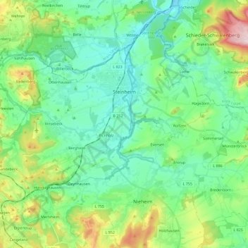
Name: Steinheim topographic map, elevation, terrain.
Location: Steinheim, Kreis Höxter, North Rhine-Westphalia, 32839, Germany (51.78411 8.95028 51.91142 9.17695)
Average elevation: 200 m
Minimum elevation: 119 m
Maximum elevation: 438 m
Other topographic maps
Click on a map to view its topography, its elevation and its terrain.
Borgentreich
Germany > North Rhine-Westphalia > Kreis Höxter
Borgentreich, Kreis Höxter, North Rhine-Westphalia, 34434, Germany
Average elevation: 233 m
Warburg
Germany > North Rhine-Westphalia > Kreis Höxter
Warburg, Kreis Höxter, North Rhine-Westphalia, 34414, Germany
Average elevation: 248 m
Bad Driburg
Germany > North Rhine-Westphalia > Kreis Höxter
Bad Driburg, Kreis Höxter, North Rhine-Westphalia, 33014, Germany
Average elevation: 282 m
Steinheim
Germany > North Rhine-Westphalia > Kreis Höxter > Steinheim > Steinheim
Steinheim, Kreis Höxter, North Rhine-Westphalia, 32839, Germany
Average elevation: 166 m
Brakel
Germany > North Rhine-Westphalia > Kreis Höxter
Brakel, Kreis Höxter, North Rhine-Westphalia, 33034, Germany
Average elevation: 232 m