
Visp topographic map
Interactive map
Click on the map to display elevation.
About this map
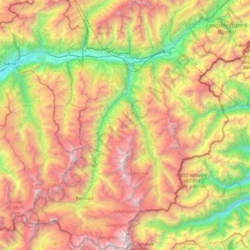
Name: Visp topographic map, elevation, terrain.
Location: Visp, Wallis, Switzerland (45.91670 7.57538 46.41894 8.03472)
Average elevation: 2,214 m
Minimum elevation: 474 m
Maximum elevation: 4,582 m
Other topographic maps
Click on a map to view its topography, its elevation and its terrain.
Barrage de Cleuson
Switzerland > Wallis > Conthey > Nendaz
Barrage de Cleuson, Nendaz, Conthey, Wallis, 1997, Switzerland
Average elevation: 2,282 m
Saas-Grund
Switzerland > Wallis > Visp
Saas-Grund, Visp, Wallis, 3910, Switzerland
Average elevation: 2,317 m
Oberwald
Switzerland > Wallis > Goms > Obergoms
Oberwald, Obergoms, Goms, Wallis, 3999, Switzerland
Average elevation: 1,744 m
Verbier
Switzerland > Wallis > Entremont
Verbier, Val de Bagnes, Entremont, Wallis, 1934, Switzerland
Average elevation: 1,626 m
Binntal
Switzerland > Wallis > Östlich Raron > Grengiols
Binntal, Grengiols, Östlich Raron, Wallis, 3993, Switzerland
Average elevation: 2,019 m
Hérémence
Switzerland > Wallis > Hérens
Hérémence, Hérens, Wallis, 1987, Switzerland
Average elevation: 2,329 m