
Thank you for supporting this site ❤️
Make a donation
Make a donation
Les Terrasses topographic map
Click on the map to display elevation.
Thank you for supporting this site ❤️
Make a donation
Make a donation
About this map
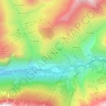
Name: Les Terrasses topographic map, elevation, terrain.
Average elevation: 1,827 m
Minimum elevation: 1,337 m
Maximum elevation: 2,417 m
Thank you for supporting this site ❤️
Make a donation
Make a donation
Other topographic maps
Click on a map to view its topography, its elevation and its terrain.
Glacier du Tabuchet
France > Provence-Alpes-Côte d'Azur > Hautes-Alpes > La Grave
Average elevation: 3,077 m
Glacier de la Meije
France > Provence-Alpes-Côte d'Azur > Hautes-Alpes > La Grave
Average elevation: 3,065 m
Glacier de la Girose
France > Provence-Alpes-Côte d'Azur > Hautes-Alpes > La Grave
Average elevation: 3,051 m
Glacier de l'Homme
France > Provence-Alpes-Côte d'Azur > Hautes-Alpes > La Grave
Average elevation: 3,169 m
Thank you for supporting this site ❤️
Make a donation
Make a donation
Refuge du Pic du Mas de la Grave
France > Provence-Alpes-Côte d'Azur > Hautes-Alpes > La Grave > Rivet du Pied
Average elevation: 2,119 m