
Chișinău Municipality topographic map
Interactive map
Click on the map to display elevation.
About this map
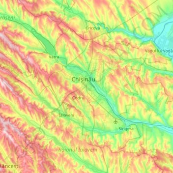
Name: Chișinău Municipality topographic map, elevation, terrain.
Location: Chișinău Municipality, Moldova (46.85810 28.55727 47.15636 29.12365)
Average elevation: 136 m
Minimum elevation: 10 m
Maximum elevation: 333 m
Other topographic maps
Click on a map to view its topography, its elevation and its terrain.
Tiraspol City Council
Tiraspol City Council, Administrative-Territorial Units of the Left Bank of the Dniester, Pridnestrovie, Moldova
Average elevation: 47 m
посёлок Геологов
Moldova > Transnistria > Dubăsari town council
посёлок Геологов, Dubăsari town council, Dubossary District, Administrative-Territorial Units from the Left Bank of the Dniester, Transnistria, 4520, Moldova
Average elevation: 31 m