
Make a donation
Adda topographic map
Click on the map to display elevation.
Make a donation
About this map
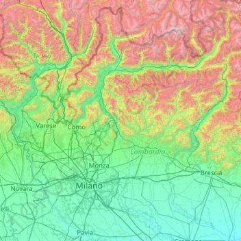
Name: Adda topographic map, elevation, terrain.
Location: Adda, 23883, Italy (45.13409 9.27283 46.54985 10.35974)
Average elevation: 870 m
Minimum elevation: 24 m
Maximum elevation: 4,001 m
Make a donation
Other topographic maps
Click on a map to view its topography, its elevation and its terrain.
Monte Terminillo
Italy > Lazio > Rieti > Micigliano
Monte Terminillo is a massif in the Monti Reatini, part of the Abruzzi Apennine range in central Italy. It is located some 20 km from Rieti and 100 km from Rome and has a highest altitude of 2,217 metres (7,274 ft).
Average elevation: 1,834 m
Make a donation
Make a donation
Make a donation
Campitello Matese
Italy > Molise > Campobasso
Campitello Matese is a location known to cycling fans for being several times during the coming stage of the Giro d'Italia: the first in 1969, the last in 2002. The characteristics of the ascent from San Massimo Campitello (13.5 miles long and 850 m in altitude, average slope of 6.4%) make it one of the most…
Average elevation: 1,410 m
Make a donation
Make a donation
La Camosciara
Italy > Trentino – Alto Adige/Südtirol > Provincia di Trento > Vallelaghi > Monte Terlago
Average elevation: 1,000 m
Make a donation
San Nicolò a Trebbia
Italy > Emilia-Romagna > San Nicolò a Trebbia > Rottofreno
Average elevation: 62 m
Make a donation
Matterhorn
Italy > Aosta Valley > Valtournenche
In 1999, the summit height was precisely determined to be at 4,477.54 m (14,690 ft) above sea level by using Global Positioning System technology as part of the TOWER Project (Top of the World Elevations Remeasurement) and to an accuracy of less than one centimetre, which allows future changes to be tracked.
Average elevation: 3,295 m
Make a donation