
Cinere topographic map
Interactive map
Click on the map to display elevation.
About this map
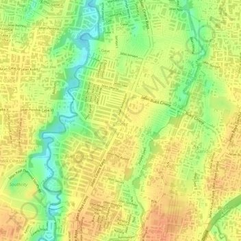
Name: Cinere topographic map, elevation, terrain.
Location: Cinere, Bogor, Java occidental, 16514, Indonésie (-6.35040 106.77241 -6.32268 106.79132)
Average elevation: 57 m
Minimum elevation: 30 m
Maximum elevation: 70 m
Other topographic maps
Click on a map to view its topography, its elevation and its terrain.
Tugu
Indonésie > Java occidental > Bogor > Depok
Tugu, Depok, Bogor, Java occidental, Jawa, 16541, Indonésie
Average elevation: 71 m