
Kehl topographic map
Interactive map
Click on the map to display elevation.
About this map
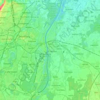
Name: Kehl topographic map, elevation, terrain.
Location: Kehl, Ortenaukreis, Baden-Vurtemberga, 77694, Alemanha (48.48625 7.79196 48.64105 7.95609)
Average elevation: 141 m
Minimum elevation: 127 m
Maximum elevation: 183 m
Other topographic maps
Click on a map to view its topography, its elevation and its terrain.
Spitzkopf
Alemanha > Baden-Vurtemberga > Ortenaukreis > Oberwolfach
Spitzkopf, Oberwolfach, Verwaltungsgemeinschaft Wolfach, Ortenaukreis, Baden-Vurtemberga, Alemanha
Average elevation: 691 m