
Neuss topographic map
Interactive map
Click on the map to display elevation.
About this map
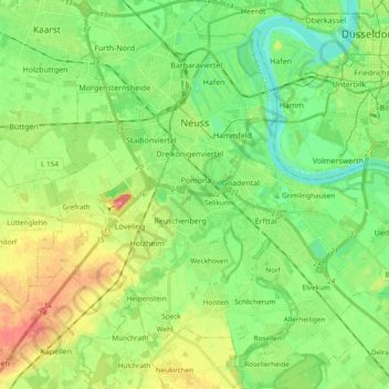
Name: Neuss topographic map, elevation, terrain.
Location: Neuss, Rhein-Kreis Neuss, Renânia do Norte-Vestfália, Alemanha (51.11676 6.61482 51.23561 6.79836)
Average elevation: 44 m
Minimum elevation: 20 m
Maximum elevation: 83 m
Other topographic maps
Click on a map to view its topography, its elevation and its terrain.
Dormagen
Alemanha > Renânia do Norte-Vestfália > Rhein-Kreis Neuss
Dormagen, Rhein-Kreis Neuss, Renânia do Norte-Vestfália, 41539, Alemanha
Average elevation: 42 m