
Andorra la Vella topographic map
Interactive map
Click on the map to display elevation.
About this map
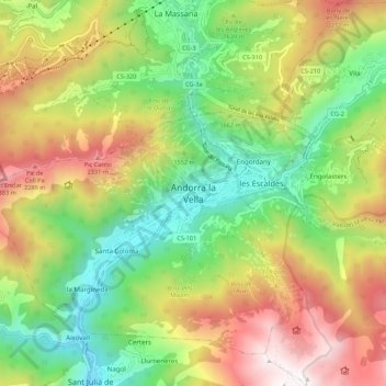
Name: Andorra la Vella topographic map, elevation, terrain.
Location: Andorra la Vella, AD500, Andorra (42.46694 1.48125 42.54694 1.56125)
Average elevation: 1,620 m
Minimum elevation: 910 m
Maximum elevation: 2,606 m
The principal industry is tourism, although the country also earns foreign income from being a tax haven. Furniture and brandies are local products. Being at an elevation of 1,023 m (3,356 ft), it is the highest capital city in Europe and a popular ski resort.