
Riyadh topographic map
Interactive map
Click on the map to display elevation.
About this map
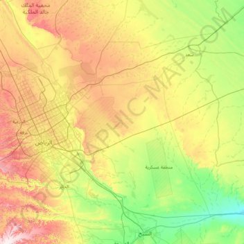
Name: Riyadh topographic map, elevation, terrain.
Location: Riyadh, Al Malaz, Riyadh Region, Saudi Arabia (24.22004 46.31679 25.26728 47.74305)
Average elevation: 658 m
Minimum elevation: 414 m
Maximum elevation: 1,079 m
Riyadh has a hot desert climate (Köppen Climate Classification BWh), with long, extremely hot summers and short, very mild winters. The average high temperature in August is 43.6 °C (110.5 °F). If it was not for the elevation the city was on, Riyadh would experience an even hotter climate. The city experiences very little precipitation, especially in summer, but receives a fair amount of rain in March and April. It is also known to have dust storms during which the dust can be so thick that visibility is under 10 m (33 ft). On 1 and 2 April 2015, a massive dust storm hit Riyadh, causing suspension of classes in many schools in the area and cancellation of hundreds of flights, both domestic and international.