
Make a donation
Carlisle topographic map
Click on the map to display elevation.
Make a donation
About this map
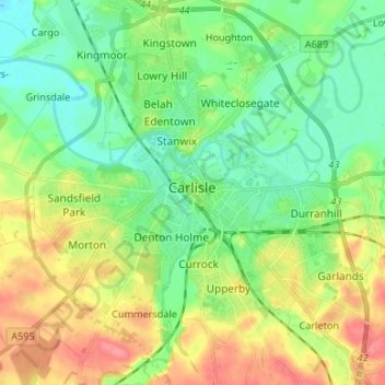
Name: Carlisle topographic map, elevation, terrain.
Location: Carlisle, Cumberland, England, United Kingdom (54.85565 -2.98940 54.93207 -2.87749)
Average elevation: 31 m
Minimum elevation: 5 m
Maximum elevation: 75 m
Make a donation
Other topographic maps
Click on a map to view its topography, its elevation and its terrain.
Make a donation
Make a donation
Scafell Pike
United Kingdom > England > Cumberland
Scafell Pike (/ˈskɔːfɛl paɪk/) is the highest and the most prominent mountain in England, at an elevation of 978 metres (3,209 ft) above sea level. It is located in the Lake District National Park, in Cumbria, and is part of the Southern Fells and the Scafell massif.
Average elevation: 679 m
Make a donation
Make a donation
High Rigg
United Kingdom > England > Cumberland
High Rigg is a small fell located in the English Lake District, approximately three miles southeast of the town of Keswick. It occupies an unusual position, surrounded on all sides by higher fells but not connected by any obvious ridge. This separation from its fellows ensures that it is a Marilyn (a hill with…
Average elevation: 205 m
Make a donation
Setmurthy Common
United Kingdom > England > Cumberland > Embleton > Setmurthy
Average elevation: 151 m
Make a donation
Seathwaite Fell (Wainwright)
United Kingdom > England > Cumberland > Borrowdale
Average elevation: 511 m
High Spy
United Kingdom > England > Cumberland
The fell reaches a height of 653 metres (2,142 feet) and is defended by crags to the east and west as it falls away steeply to the valleys. It is a distinctive fell that has 148 metres (486 feet) of topographic prominence from the higher adjoining fell of Dale Head and so misses being a Marilyn by only two…
Average elevation: 404 m
Make a donation
Fellbarrow
United Kingdom > England > Cumberland
The two fells form a ridge 2 miles long with the lower Fellbarrow at the northern end. Alfred Wainwright in his influential Pictorial Guide to the Lakeland Fells was forced to estimate the elevation of Low Fell and considered (although with some doubts) Fellbarrow to be the high point of the ridge. There are a…
Average elevation: 256 m
Make a donation
Seatallan
United Kingdom > England > Cumberland
Seatallan is a mountain in the western part of the English Lake District. It is rounded, grassy and fairly unassuming, occupying a large amount of land. However, it is classed as a Marilyn because of the low elevation of the col connecting it to Haycock, its nearest higher neighbour to the north. The name…
Average elevation: 452 m
Make a donation
Crosby-on-Eden
United Kingdom > England > Cumberland > Low Crosby > High Crosby
Average elevation: 22 m
Make a donation
Whin Rigg
United Kingdom > England > Cumberland
Whin Rigg is a fell in the English Lake District, situated in the western segment of the national park, 22 kilometres (14 miles) south east of the town of Whitehaven. It reaches only a modest altitude of 535 m (1,755 ft) but is part of one of the Lake District’s most dramatic landscapes in that the rugged…
Average elevation: 264 m
Make a donation
Cockermouth
United Kingdom > England > Cumberland
Cockermouth has a temperate climate that is influenced by the Irish Sea and its low-lying elevation. Cockermouth receives slightly below average rainfall compared with the UK average. Temperatures are also round about average compared with other parts of the UK. The nearest weather station for which online…
Average elevation: 86 m
Make a donation
Make a donation
Hay Stacks
United Kingdom > England > Cumberland
Haystacks, or Hay Stacks, is a hill in England's Lake District, situated at the south-eastern end of the Buttermere Valley. Although not of any great elevation (597 m, 1,958 ft), Haystacks has become one of the most popular fells in the area. This fame is partly due to the writings of Alfred Wainwright, who…
Average elevation: 386 m
Make a donation
Setmurthy
United Kingdom > England > Cumberland
Watch Hill, also known as Setmurthy Common, reaches 254 metres (833 ft) and because of its relative isolation qualifies as a marilyn, a hill with 150 m of topographic prominence. Alfred Wainwright includes it in his The Outlying Fells of Lakeland, recommending an ascent from the west and a return on the same…
Average elevation: 142 m
Make a donation
Make a donation
Make a donation
Make a donation
Make a donation
Make a donation
Make a donation
Make a donation
Make a donation
Hardknott Pass
United Kingdom > England > Cumberland > Ulpha
The Hardknott Pass stands at a maximum elevation of 393 m (1,289 ft). The road descends steeply at a gradient of 30% (1 in 3) into the Duddon Valley. At the eastern end of the pass is Cockley Beck farm, built in the 1860s and owned by the National Trust. The route from Hardknott leads eastward towards the…
Average elevation: 323 m
Make a donation
Make a donation