
County Antrim topographic map
Interactive map
Click on the map to display elevation.
About this map
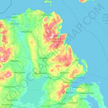
Name: County Antrim topographic map, elevation, terrain.
Location: County Antrim, Nordirland, Vereinigtes Königreich (54.47728 -6.66899 55.31309 -5.68796)
Average elevation: 70 m
Minimum elevation: -1 m
Maximum elevation: 549 m
Other topographic maps
Click on a map to view its topography, its elevation and its terrain.
Glenoe
Vereinigtes Königreich > Nordirland > County Antrim > Glenoe
Glenoe, County Antrim, Nordirland, BT40 3DU, Vereinigtes Königreich
Average elevation: 144 m
Bushmills
Vereinigtes Königreich > Nordirland > County Antrim > Bushmills
Bushmills, County Antrim, Nordirland, BT57 8QB, Vereinigtes Königreich
Average elevation: 42 m
Ballyrobert
Vereinigtes Königreich > Nordirland > County Antrim > Ballyrobert
Ballyrobert, County Antrim, Nordirland, BT39 9RX, Vereinigtes Königreich
Average elevation: 106 m