
Fagradalsfjall topographic map
Interactive map
Click on the map to display elevation.
About this map
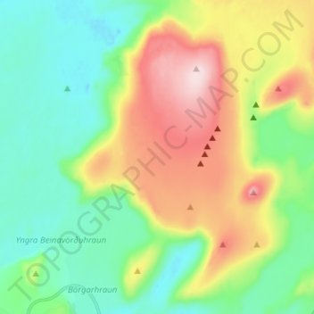
Name: Fagradalsfjall topographic map, elevation, terrain.
Location: Fagradalsfjall, Grindavíkurbær, Southern Peninsula, Iceland (63.86169 -22.33207 63.91728 -22.23942)
Average elevation: 163 m
Minimum elevation: 48 m
Maximum elevation: 382 m
Other topographic maps
Click on a map to view its topography, its elevation and its terrain.
Grindavík
Grindavík, Grindavíkurbær, Southern Peninsula, 240, Iceland
Average elevation: 27 m
Litli-Hrútur
Litli-Hrútur, Grindavíkurbær, Southern Peninsula, Iceland
Average elevation: 220 m
Geldingadalir
Geldingadalir, Grindavíkurbær, Southern Peninsula, Iceland
Average elevation: 256 m
Langhóll
Langhóll, Grindavíkurbær, Southern Peninsula, Iceland
Average elevation: 244 m