
Philadelphia topographic map
Interactive map
Click on the map to display elevation.
About this map
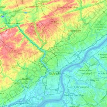
Name: Philadelphia topographic map, elevation, terrain.
Average elevation: 44 m
Minimum elevation: -40 m
Maximum elevation: 155 m
Die durchschnittliche Höhe Philadelphias beträgt 12 Meter über dem Meeresspiegel. Der niedrigste Punkt der Stadt liegt bei drei Metern. Der Höchste ist der Chestnut Hill in der Nähe von German Town mit 136 Metern über Normalnull. Die Stadt liegt auf der Fall Line, die die Atlantische Küstenebene von Piedmont trennt.
Other topographic maps
Click on a map to view its topography, its elevation and its terrain.
Philadelphia
Vereinigte Staaten von Amerika > Pennsylvania > Philadelphia County > Philadelphia
Philadelphia, Philadelphia County, Pennsylvania, 19110, Vereinigte Staaten von Amerika
Average elevation: 35 m