
Rettenbach topographic map
Interactive map
Click on the map to display elevation.
About this map
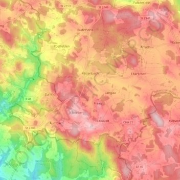
Name: Rettenbach topographic map, elevation, terrain.
Average elevation: 579 m
Minimum elevation: 405 m
Maximum elevation: 681 m
Other topographic maps
Click on a map to view its topography, its elevation and its terrain.
Kapelhof
Duitsland > Beieren > Landkreis Cham > Roding
Kapelhof, Roding, Landkreis Cham, Beieren, 93426, Duitsland
Average elevation: 427 m