
Bella Vista topographic map
Interactive map
Click on the map to display elevation.
About this map
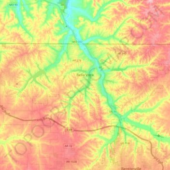
Name: Bella Vista topographic map, elevation, terrain.
Location: Bella Vista, Benton County, Arkansas, 72715, United States (36.41540 -94.37568 36.49960 -94.16197)
Average elevation: 372 m
Minimum elevation: 283 m
Maximum elevation: 447 m
The city of Bella Vista is located on the Springfield Plateau of the Ozark Mountains. Oak/hickory forests, along with valleys, creeks, and steep rises, characterize the city's topography. Bella Vista is located north of Bentonville and Rogers within the Northwest Arkansas region. The city has been experiencing a population and building boom in recent years, as indicated by a 60% growth in population between the 2000 and 2010 censuses.
Other topographic maps
Click on a map to view its topography, its elevation and its terrain.
Bella Vista Lake
United States > Arkansas > Benton County > Bentonville
Bella Vista Lake, Bentonville, Benton County, Arkansas, United States
Average elevation: 351 m
Siloam Springs
United States > Arkansas > Benton County > Siloam Springs
Siloam Springs, Benton County, Arkansas, United States
Average elevation: 339 m
Bella Vista
United States > Arkansas > Benton County > Bella Vista
Bella Vista, Benton County, Arkansas, 72715, United States
Average elevation: 371 m