
Thank you for supporting this site ❤️
Make a donation
Make a donation
Almeria topographic map
Click on the map to display elevation.
Thank you for supporting this site ❤️
Make a donation
Make a donation
About this map
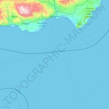
Name: Almeria topographic map, elevation, terrain.
Location: Almeria, Andalusia, Spain (35.93764 -3.03721 37.00001 -2.20220)
Average elevation: 97 m
Minimum elevation: -3 m
Maximum elevation: 2,221 m
Thank you for supporting this site ❤️
Make a donation
Make a donation
Other topographic maps
Click on a map to view its topography, its elevation and its terrain.