
Lake Powell topographic map
Interactive map
Click on the map to display elevation.
About this map
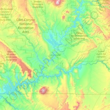
Name: Lake Powell topographic map, elevation, terrain.
Location: Lake Powell, San Juan County, Utah, États-Unis d'Amérique (36.84441 -111.56748 37.90938 -110.28672)
Average elevation: 1,555 m
Minimum elevation: 1,103 m
Maximum elevation: 3,236 m
Other topographic maps
Click on a map to view its topography, its elevation and its terrain.
Plateau du Colorado
États-Unis d'Amérique > Utah > San Juan County
Plateau du Colorado, Western Navajo Agency / Tó Naneesdizí Bił Hahoodzo biyiʼdi, San Juan County, Utah, États-Unis d'Amérique
Average elevation: 1,512 m
Navajo Mountain
États-Unis d'Amérique > Utah > San Juan County
Navajo Mountain, San Juan County, Utah, États-Unis d'Amérique
Average elevation: 1,806 m