
Lima Metropolitan Area topographic map
Interactive map
Click on the map to display elevation.
About this map
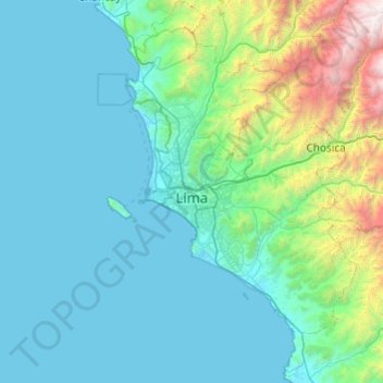
Name: Lima Metropolitan Area topographic map, elevation, terrain.
Location: Lima Metropolitan Area, Lima, Peru (-12.51993 -77.19921 -11.57244 -76.62082)
Average elevation: 591 m
Minimum elevation: 0 m
Maximum elevation: 4,883 m
Other topographic maps
Click on a map to view its topography, its elevation and its terrain.
Lima
Relative humidity is always very high, particularly in the mornings. High humidity produces brief morning fog in the early summer and a usually persistent low cloud deck during the winter (generally develops in late May and persists until mid-November or even early December). The predominantly onshore flow…
Average elevation: 202 m