
Thank you for supporting this site ❤️
Make a donation
Make a donation
Rosemarkie topographic map
Click on the map to display elevation.
Thank you for supporting this site ❤️
Make a donation
Make a donation
About this map
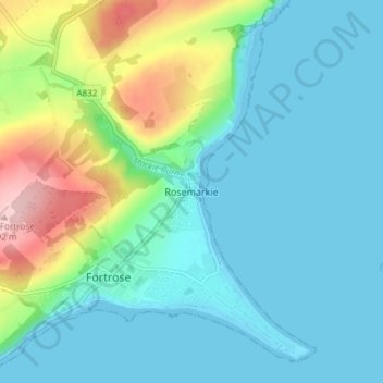
Name: Rosemarkie topographic map, elevation, terrain.
Location: Rosemarkie, Highland, Scotland, IV10 8UJ, United Kingdom (57.57069 -4.13431 57.61069 -4.09431)
Average elevation: 44 m
Minimum elevation: -1 m
Maximum elevation: 193 m
Thank you for supporting this site ❤️
Make a donation
Make a donation
Other topographic maps
Click on a map to view its topography, its elevation and its terrain.