
Bharananganam topographic map
Interactive map
Click on the map to display elevation.
About this map
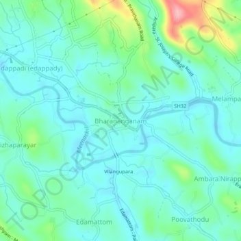
Name: Bharananganam topographic map, elevation, terrain.
Average elevation: 40 m
Minimum elevation: 9 m
Maximum elevation: 151 m
Other topographic maps
Click on a map to view its topography, its elevation and its terrain.
Cherppungal Kulam Cheripurathu Padasekaram Karikombu
India > Kerala > Meenachil > Cherpunkal
Average elevation: 29 m