
Lapa topographic map
Interactive map
Click on the map to display elevation.
About this map
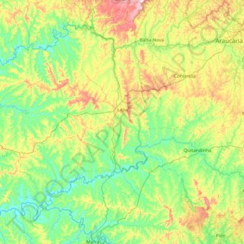
Name: Lapa topographic map, elevation, terrain.
Average elevation: 868 m
Minimum elevation: 762 m
Maximum elevation: 1,134 m
Lapa liegt auf dem Übergang vom Segundo Planalto Paranaense (der Zweiten oder Ponta-Grossa-Hochebene von Paraná) zum Primeiro Planalto Paranaense. Seine Fläche beträgt 2094 km². Es liegt auf einer Höhe von 926 Metern.
Other topographic maps
Click on a map to view its topography, its elevation and its terrain.
Curitiba
Brasilien > Paraná > Região Metropolitana de Curitiba
Curitiba, Região Geográfica Imediata de Curitiba, Região Metropolitana de Curitiba, Região Geográfica Intermediária de Curitiba, Paraná, Süden, Brasilien
Average elevation: 911 m