
Sankt Michael topographic map
Interactive map
Click on the map to display elevation.
About this map
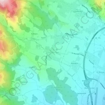
Name: Sankt Michael topographic map, elevation, terrain.
Average elevation: 525 m
Minimum elevation: 436 m
Maximum elevation: 834 m
Other topographic maps
Click on a map to view its topography, its elevation and its terrain.
Siegelsdorf
Österreich > Kärnten > Bezirk Wolfsberg > Wolfsberg
Siegelsdorf, Wolfsberg, Bezirk Wolfsberg, Kärnten, 9400, Österreich
Average elevation: 530 m
Hartelsberg
Österreich > Kärnten > Bezirk Wolfsberg > Wolfsberg
Hartelsberg, Wolfsberg, Bezirk Wolfsberg, Kärnten, 9400, Österreich
Average elevation: 774 m
Altendorf
Österreich > Kärnten > Bezirk Wolfsberg > Wolfsberg > Hattendorf > Altendorf
Altendorf, Hattendorf, Wolfsberg, Bezirk Wolfsberg, Kärnten, 9400, Österreich
Average elevation: 483 m