
Thank you for supporting this site ❤️
Make a donation
Make a donation
Matana Madh topographic map
Click on the map to display elevation.
Thank you for supporting this site ❤️
Make a donation
Make a donation
About this map
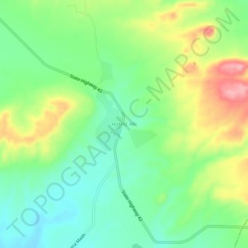
Name: Matana Madh topographic map, elevation, terrain.
Location: Matana Madh, Lakhpat Taluka, Kachchh, Gujarat, 370625, India (23.52255 68.93103 23.56255 68.97103)
Average elevation: 120 m
Minimum elevation: 68 m
Maximum elevation: 208 m
Thank you for supporting this site ❤️
Make a donation
Make a donation
Other topographic maps
Click on a map to view its topography, its elevation and its terrain.